Cape Coral Canal Guide
Cape Coral Canal Guide
A Local Guide to Gulf Access, Sailboat Access & Freshwater Canals in Southwest Florida
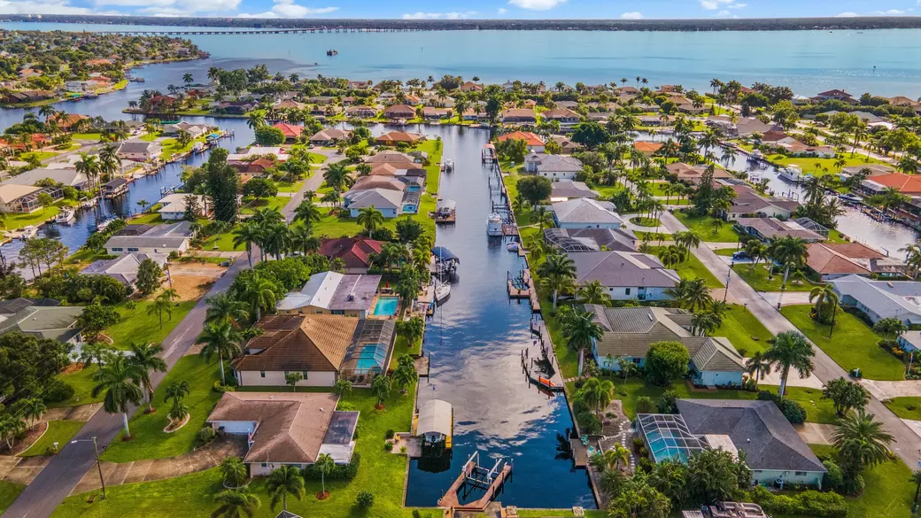
Cape Coral’s canal system is one of the most unique — and most confusing — waterfront networks in the country. With 400+ miles of canals, varying bridge heights, route times, canal widths, and access types, even seasoned agents can be inconsistent in how they explain it.
This guide breaks everything down simply and accurately so you can choose the right home, the right canal, and the right lifestyle.
And because every street, bridge, and basin is different, it’s essential to work with a local agent who understands Cape Coral’s waterways block by block.
🚤 1. The Two Main Canal Types in Cape Coral
Cape Coral’s canals fit into two categories:
1️⃣ Gulf Access (Saltwater Canals)
These canals connect to the Caloosahatchee River → Charlotte Harbor → San Carlos Bay → the Gulf of Mexico.
There are two subtypes of Gulf Access:
A. Bridged Gulf Access (Most Common)
✔ Saltwater
✔ Connects to the Gulf
✔ Has one or more bridges
✔ Great for center consoles, pontoons, tritoons, deck boats
Important factors:
-
Bridge clearance (8.5–13 ft at high tide)
-
Tide changes (~1 ft difference)
-
Some routes have 2, 3, or even 4 bridges
-
Long canal rides depending on location
-
Boat height, tower height, and bimini height all matter
B. Sailboat Access (No Bridges)
✔ Still saltwater / Gulf Access
✔ Zero bridges
✔ No height restrictions
✔ Deeper canals
✔ Perfect for large vessels, sailboats, flybridges, and cabin cruisers
Common areas with sailboat access:
-
Yacht Club
-
Savona / Pelican Blvd SE
-
Tarpon Point / Rose Garden
-
Everest / Gold Coast area
Note:
Even in sailboat-access areas, overhead utility lines exist — for example, a major line crosses Bimini Basin, which matters for very tall masts.
2️⃣ Freshwater Canals (Non-Gulf Access)
Freshwater canals are interior canals that do not connect to the Gulf.
✔ Perfect for kayaking, paddleboarding, and freshwater fishing
✔ Peaceful and private
✔ No tide impact
✔ Lower seawall maintenance
✔ Budget-friendly waterfront
Mostly located in North Cape, with a few isolated pockets elsewhere.
🗺️ 2. Canal Location Matters - A Lot
Your “time to open water” is one of the biggest pricing factors for Gulf Access homes.
Here’s how to understand the geography:
⭐ Fastest Access (5–25 minutes to open water)
Southeast Cape Coral
-
Yacht Club
-
Savona
-
Pelican Blvd SE
-
Everest / Gold Coast
-
Rosen Park area
These areas command higher prices due to short boating times.
⭐ Medium Access (25–60 minutes)
Southwest Cape Coral
Especially between Chiquita → Surfside, and areas near Veterans Memorial Pkwy.
-
Varying bridge counts
-
More twists and turns
-
Tidal influence
-
Some streets are quick; others surprisingly long
Some southwest sections can require 45–90 minutes — not just NW Cape.
⭐ Longest Access (60–90+ minutes)
Northwest Cape Coral / Spreader Canal
-
Long bends
-
Idle zones
-
Narrower canals in some pockets
-
Beautiful but farther from open water
⭐ Freshwater Areas
North Cape Coral
-
Dozens of freshwater canals
-
Lakes with beautiful views
-
Great for kayaks, quiet living
-
No Gulf access
🛑 3. Bridge Height, Depth, Utility Lines & “Misleading Canals”
Bridge Height
Bridge clearance determines whether your boat will fit.
-
Typical clearance: 8.5–13 ft at mean high tide
-
Tide changes can add/subtract ~1 ft
-
Some routes have multiple bridges
-
MLS often does not list exact bridge heights
Boats affected:
-
Center consoles
-
Wake boats
-
Pontoon biminis
-
Dual consoles
-
Cabin cruisers
-
Flybridges
-
Sailboats (must avoid all bridges)
Depth
Most Gulf Access canals: 6–8 ft
But:
-
NW has more tidal variation
-
Canals near Matlacha Pass can be shallower
-
Turning basins = deeper
Overhead Utility Lines
Certain areas have overhead lines tall boats must consider:
-
A major overhead line in Bimini Basin
-
Older utility easements in SE Cape
-
Some powerline corridors in older neighborhoods
⚠️ “Misleading Canals” - They Look Navigable, But Aren’t
One of the easiest mistakes buyers make:
Some canals look wide, open, and boat-friendly…
but in reality, they are not navigable due to:
-
A very low bridge
-
A road crossing
-
A culvert instead of a full bridge
-
Extremely low, tight passages where even a kayak won’t fit
These occur most often in older Southeast sections and scattered pockets throughout the Northeast, but they can appear anywhere in the city.
This is why looking at a “map view” is NOT enough.
Before buying waterfront, a knowledgeable agent should verify:
-
Route via iBoatMap
-
Bridge count
-
Bridge height
-
Depth
-
Overhead lines
-
Canal width
-
Whether the canal actually connects to the system
This prevents buying a “gulf access” home that simply… isn’t.
Here is a link to a few resouces that may help in your research: https://linktr.ee/thedreierteamCapeCoralcanals
🌊 4. Gulf Access vs. Freshwater: Quick Comparison
| Canal Type | Best For | Pros | Considerations |
|---|---|---|---|
| Sailboat Access | Large, tall vessels | No bridges, deep canals | Higher prices, overhead line checks |
| Bridged Gulf Access | Most boaters | Gulf lifestyle, restaurants, fishing | Bridges + route time |
| Freshwater | Kayakers, privacy seekers | Peaceful, low maintenance | No Gulf access |
⚓ 5. Dock & Lift Considerations (Crucial for Waterfront Buyers)
If boating is part of your lifestyle, the dock and lift matter as much as the home.
Here’s what to evaluate:
Lift Weight Capacity
Common lift ratings:
-
6,000 lb
-
10,000 lb
-
13,000 lb
-
16,000 lb
-
20,000 lb+
If your boat weighs more than the lift rating, it is not safe.
Boat Type Compatibility
-
Tritoons / Pontoons: Need proper cradle design
-
Center Consoles: Often tall → bridge clearance matters
-
Wake Boats: Tall towers need measurements
-
Cabin Cruisers: Heavy → require high-capacity lifts
-
Sailboats: Cannot use lifts → tie to seawall
Canopy Height
Even if your boat clears bridges, a low canopy can still limit your boat height.
Seawall Condition
Seawall issues = expensive repairs.
Look for:
-
Bowing
-
Cracks
-
Soil erosion
-
Age vs. reinforcement
Insurance companies are increasingly strict.
Turning Radius
Wide canals and basins = easy maneuvering.
Narrow canals = challenging on windy days, especially for 30–40 ft vessels.
📱 6. Navigation Tools
👉 iBoatMap (Highly Recommended)
Great for:
-
Bridge heights
-
Idle zones
-
Restaurants
-
Marinas
-
Fuel docks
-
Route planning
-
“Is this canal actually navigable?” checks
A must-have tool for waterfront buyers and new boaters.
✨ 7. Quick-Glance Canal Table
| Canal Type | Pros | Cons | Ideal Buyer |
|---|---|---|---|
| Sailboat Access | No bridges, deep water, premium resale | Highest price | Large boats, tall vessels |
| Bridged Gulf Access | Saltwater lifestyle, restaurants, Gulf | Bridge height limits, route time | Most boaters |
| Freshwater Canals | Quiet, affordable, great views | No Gulf access | Kayakers, nature lovers |
🌴 8. Final Thoughts
Cape Coral’s canal system is beautiful, but it’s also nuanced.
Every bridge, basin, and neighborhood offers something different.
Because even local agents can disagree on access types, and because MLS does not fully reflect the complexity of the waterways, it’s important to work with a team that understands the canals firsthand.
If you’re considering a waterfront home in Cape Coral, we’ll walk you through bridge heights, route times, canal widths, and everything else that matters.
Call or Text Samantha: (218) 371-8188
📧 Email: Samantha@TheDreierTeam.com
🏡 Start your search: http://thedreierteam.com/startyoursearch
📩 Work with us: http://thedreierteam.com/workwithusdreier
✨ We make it easy. You make it home.
The Dreier Team | RE/MAX Nautical Realty